 Gallery hopping along Santa Fe's Canyon Road, we ducked into a back courtyard for some cold, iced slushies. Against a side wall, a bench fused rusted iron into a patina of light green and deep teal. I love the patchwork of sun and shadows playing on the stucco wall.
 An adobe stucco wall frames a weathered rustic wooden door in Santa Fe, New Mexico. Hernando's hideaway?
 Early morning sunlight brightens rusted wrought iron window bars guarding a teal-colored window frame in Santa Fe. Weathered, splintered, wooden beam posts (called vigas) protrude from the top of the wall.
 A black wrought iron scroll-caged window, framed in peeling teal-colored paint, complements an adobe wall in Santa Fe. A nearby hand-painted rooster crows-in the morning.
 A wooden lintel frames a blue trimmed window, accented by a gas lamp on a cracked, weather-worn adobe wall in downtown Santa Fe.
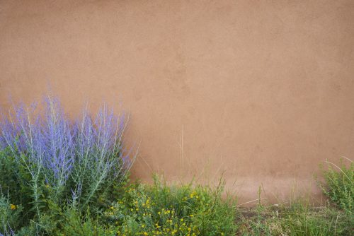 Sage shrub with lavender flowers anchor the adobe wall of an art gallery on Old Santa Fe Trail, downtown Santa Fe, New Mexico.
 The Rio Grande Gorge Bridge, located about 12-miles northwest of Taos, is purported to be the fifth highest bridge in the U.S., spanning the gorge 650-feet above the Rio Grande. This shot was taken about 1/4 mile north of the bridge. In reviewing the video afterwards, I realized the drone grazed the cliff wall—as evidenced by shaking video. Lucked out again.
 The Rio Grande Gorge Bridge, located about 12-miles northwest of Taos, is purported to be the fifth highest bridge in the U.S., spanning the gorge 650-feet above the Rio Grande. I couldn't resist flying my drone underneath the bridge, which was technically challenging from 800-feet away, above the cliff walls, in the bright sun. High five for not crashing the drone!
 The Rio Grande Gorge Bridge, located about 12-miles northwest of Taos, is purported to be the fifth highest bridge in the U.S., spanning the gorge 650-feet above the Rio Grande. I couldn't resist flying my drone underneath the bridge, which was technically challenging from 800-feet away, above the cliff walls, in the bright sun. High five for not crashing the drone!
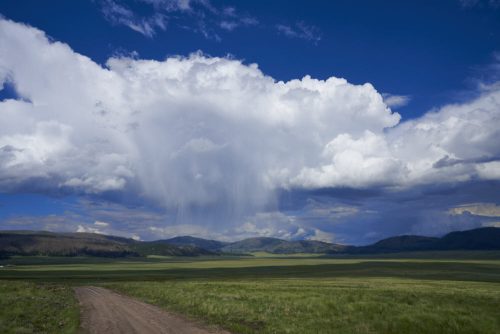 Valles Caldera National Preserve is located in the Jemez Mountain range of northern New Mexico. The volcanic eruption that occurred 1.25-million years ago left behind a 14-mile wide volcanic caldera. As we explored the preserve in our rented Highlander that afternoon, squalls streamed across the basin, illuminated by late afternoon sun.
 The Inn and Spa at Loretto is located on the Old Santa Fe Trail, just southeast of downtown Santa Fe. The hotel's abstract geometric adobe block architecture, punctuated with brown metal gutters that look like wooden support beams jutting out from the walls; and the shadows from the morning sun, caught my attention.
 Walking Old Town Albuquerque (a touristy attraction comprised mostly of trinket shops) I turned down a side alley to find this simple adobe wall with wooden support beams (technical term: vigas), casting long shadows at a 45-degree angle across the stucco canvas.
 A stone walkway with arched teal door at the church of Saint John the Baptist in the village of San Juan Bautista Suchix Hahuca. Construction for this Renaissance architecture church was completed in 1576. Bekki and I traveled to Oaxaca, Mexico, February of 2020 with my sister and brother-in-law who organize cultural trips to Central America and Mexico.
 Three long-forgotten, dust-coated, blue ceramic urns sit abandoned on a dusty table in the organ loft of the church of Saint John the Baptist in the village of San Juan Bautista Suchix Hahuca. Old wooden candlesticks lie strewn about the table. A still life image caught in time. Bekki and I traveled to Oaxaca, Mexico, February of 2020 with my sister and brother-in-law who organize cultural trips to Central America and Mexico.
 Prior to Ash Wednesday the village of Tilcajete, near Oaxaca, celebrates carnival with imaginative animal and creature masks in chanting, grunting, colorful processions. Here, a carnival celebrant parades through the dusty village streets with his group of similarly-costumed friends. The cowbells strapped around his waist clang and and jangle as he grunts and dances. Bekki and I traveled to Oaxaca, Mexico, February of 2020 with my sister and brother-in-law who organize cultural trips to Central America and Mexico.
 Prior to Ash Wednesday the village of Tilcajete, near Oaxaca, celebrates carnival with imaginative animal and creature masks in chanting, grunting, colorful processions. Here, a carnival celebrant wears blue face paint with a peacock head dress. (I have a similar shot of her male companion.) Bekki and I traveled to Oaxaca, Mexico, February of 2020 with my sister and brother-in-law who organize cultural trips to Central America and Mexico.
 Prior to Ash Wednesday the village of Tilcajete, near Oaxaca, celebrates carnival with imaginative animal and creature masks in chanting, grunting, colorful processions. Here, a carnival celebrant wears blue face paint with a jaguar mask on top of his head, and peacock feathers fanned out behind his head. (I have a similar shot of his female companion.) Bekki and I traveled to Oaxaca, Mexico, February of 2020 with my sister and brother-in-law who organize cultural trips to Central America and Mexico.
 Red bull alebrijes carving in the Isaias Jimenez’s studio located in the small town of Arrazola, about 4-miles southwest of Oaxaca. Isaias continues the Oaxacan alebrijes style created by his father Manuel Jiménez Ramírez (who has his own Wikipedia page). Alebrijes are a style of brightly colored Mexican folk art sculptures of imaginary and mythical creatures. Bekki and I traveled to Oaxaca, Mexico, February of 2020 with my sister and brother-in-law who organize cultural trips to Central America and Mexico.
 People gather in the Plaza de la Danza (literally, "dance square") at dusk, adjacent to the Basilica of Our Lady of Solitude in Oaxaca, Mexico. Families still gather socially in plazas and squares throughout Mexico. This plaza was very close to our hotel, so we walked past it almost every evening. I thought it was a quintessential Mexican scene: a plaza with families and friends adjacent to the church and lights twinkling on the distant mountain as twilight fades to night. Bekki and I traveled to Oaxaca, Mexico, February of 2020 with my sister and brother-in-law who organize cultural trips to Central America and Mexico.
 Close up of a basket of red and green peppers for sale at the Benito Juarez market in Oaxaca, Mexico. This 3-foot wide basket of peppers completely covered the spectrum from green, yellow, orange, and bright red. Bekki and I traveled to Oaxaca, Mexico, February of 2020 with my sister and brother-in-law who organize cultural trips to Central America and Mexico. While the Benito Juarez Market isn't the only market in Oaxaca, it's a large and vibrant one with over 360 vendors selling ... everything.
 The 22nd Hobie 16 World race was held on Captiva Island, Florida, on November, 2019. A woman watches one of the races from the official observation boat.
 The 22nd Hobie 16 World race was held on Captiva Island, Florida, on November, 2019. Sailors hike out to windward to counter the force of the wind on the sails during one of the races. The starboard pontoon is about 5-6 feet out of the water.
 The 22nd Hobie 16 World race was held on Captiva Island, Florida, on November, 2019. A 16' Hobie Cat points into the wind during one of the races as the port side pontoon throws spray from the leeward side of the cat.
 The 22nd Hobie 16 World race was held on Captiva Island, Florida, on November, 2019. 11 Hobie Cats point to windward during one of the races, framed by a backdrop of blue clouds floating in a light blue sky.
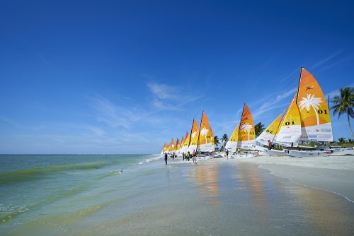 The 22nd Hobie 16 World race was held on Captiva Island, Florida, on November, 2019. Hobie Cats line the beach between races. This image forms a color wheel clockwise from the white sand to the green waves, teal-colored ocean, blue sky, around to the orange and white sails.
 Early morning sunrise on First Street in downtown Fort Myers. I wanted to capture the historic district of Fort Myers without the usual traffic and tourists. Shot was taken 5:00 a.m. on a Sunday morning.
 Early morning sunrise on First Street in downtown Fort Myers. I wanted to capture the historic district of Fort Myers without the usual traffic and tourists. Shot was taken 5:00 a.m. on a Sunday morning.
 Early morning sunrise on First Street in downtown Fort Myers. I wanted to capture the historic district of Fort Myers without the usual traffic and tourists. Shot was taken 5:00 a.m. on a Sunday morning.
 Elaborate lighting systems illuminate South Beach's Ocean Drive at night. This is one of a series of drone shots which required three separate trips to South Beach. The shots were technically difficult because of pedestrians, vehicles, and stiff breezes off of the Atlantic Ocean. This shot is of the Colony and Boulevard Hotels.
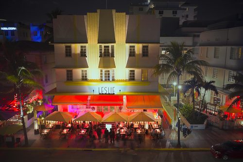 Elaborate lighting systems illuminate South Beach's Ocean Drive at night. This is one of a series of drone shots which required three separate trips to South Beach. The shots were technically difficult because of pedestrians, vehicles, and stiff breezes off of the Atlantic Ocean. This shot is of the Leslie Hotel.
 Elaborate lighting systems illuminate South Beach's Ocean Drive at night. This is one of a series of drone shots which required three separate trips to South Beach. The shots were technically difficult because of pedestrians, vehicles, and stiff breezes off of the Atlantic Ocean. This shot is of Havana 1957—an authentic Cuban restaurant.
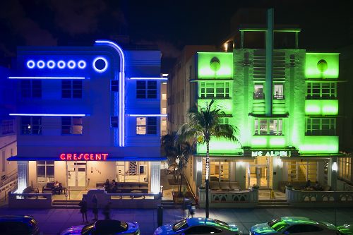 Elaborate lighting systems illuminate South Beach's Ocean Drive at night. This is one of a series of drone shots which required three separate trips to South Beach. The shots were technically difficult because of pedestrians, vehicles, and stiff breezes off of the Atlantic Ocean. This shot is of the Crescent Resort on the left, with the Mc Alpin on the right.
 Elaborate lighting systems illuminate South Beach's Ocean Drive at night. This is one of a series of drone shots which required three separate trips to South Beach. The shots were technically difficult because of pedestrians, vehicles, and stiff breezes off of the Atlantic Ocean. This shot is of the Avalon hotel with a vintage yellow and white 1957 Chevy convertible parked in front.
 Elaborate lighting systems illuminate South Beach's Ocean Drive at night. This is one of a series of drone shots which required three separate trips to South Beach. The shots were technically difficult because of pedestrians, vehicles, and stiff breezes off of the Atlantic Ocean. This shot is of the Breakwater hotel.
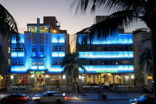 Elaborate lighting systems illuminate South Beach's Ocean Drive at night. This is one of a series of drone shots which required three separate trips to South Beach. The shots were technically difficult because of pedestrians, vehicles, and stiff breezes off of the Atlantic Ocean. This shot is of the McAlpin and Ocean Plaza Hotels.
 Elaborate lighting systems illuminate South Beach's Ocean Drive at night. This is one of a series of drone shots which required three separate trips to South Beach. The shots were technically difficult because of pedestrians, vehicles, and stiff breezes off of the Atlantic Ocean. A shot of Mango's Tropical Cafe.
 Elaborate lighting systems illuminate South Beach's Ocean Drive at night. This is one of a series of drone shots which required three separate trips to South Beach. The shots were technically difficult because of pedestrians, vehicles, and stiff breezes off of the Atlantic Ocean. This shot looks west to the Miami Skyline above the Breakwater Hotel.
 I shot several images of the Cuba Tobacco Cigar Company during a shooting trip to Little Havana in Miami. The store owner takes a break to enjoy one of his own cigars . Little Havana is a neighborhood in Miami that is home to many Cuban exiles. The neighborhood is known for Cuban culture, food, and cigars.
 I shot several images of the Cuba Tobacco Cigar Company during a shooting trip to Little Havana in Miami. The store owner takes a break to enjoy one of his own cigars . Little Havana is a neighborhood in Miami that is home to many Cuban exiles. The neighborhood is known for Cuban culture, food, and cigars.
 I shot several images of the Cuba Tobacco Cigar Company during a shooting trip to Little Havana in Miami. A worker hand cuts and hand rolls cigars in the store. Little Havana is a neighborhood in Miami that is home to many Cuban exiles. The neighborhood is known for Cuban culture, food, and cigars.
 I shot several images of the Cuba Tobacco Cigar Company during a shooting trip to Little Havana in Miami. A worker makes hand cut and hand rolled cigars. Little Havana is a neighborhood in Miami that is home to many Cuban exiles. The neighborhood is known for Cuban culture, food, and cigars.
 I shot several images of the Cuba Tobacco Cigar Company during a shooting trip to Little Havana in Miami. Here the store owners inspect a shipment of tobacco leaves in preparation for cutting and rolling. Little Havana is a neighborhood in Miami that is home to many Cuban exiles. The neighborhood is known for Cuban culture, food, and cigars.
 Capesterre is a sleepy village on the southwest coast of Marie-Galante—part of the French overseas region and the island of Guadeloupe. Coral reefs that have formed in the Atlantic protect its port and beautiful beaches. Image made while sailing with friends in the West Indies.
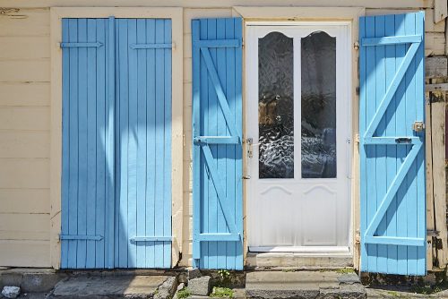 Pastel blue shutters frame a white door with textured glass in the town of Grand-Bourg, on the island of Marie-Galante. I often walk into these small towns with busy traffic and and run-down infrastructure thinking, "what am I going to shoot here?" Finding shots like this is like a treasure hunt. Image made while sailing with friends in the West Indies.
 Fishing nets laying on the jetty at the Grand-Bourg marina on the island of Marie-Galante. Image made while sailing with friends in the West Indies.
 The town of Grand-Bourg on the island of Marie-Galante, which is part of Guadeloupe, showcases some amazing murals that most visitors don't even notice. Painted on walls and buildings, framed by rusty roofs and chained link fences, I admit these murals can be somewhat camouflaged by the village. Artist unknown. Part of a diptych. Shot while sailing with friends in the West Indies.
 The town of Grand-Bourg on the island of Marie-Galante, which is part of Guadeloupe, showcases some amazing murals that most visitors don't even notice. Painted on walls and buildings, framed by rusty roofs and chained link fences, I admit these murals can be somewhat camouflaged by the village. Artist unknown. Part of a diptych. Shot while sailing with friends in the West Indies.
 Trafalgar Falls, on the island of Dominca, drops 125-feet through lush tropical foliage. Shot taken while sailing with friends in the West Indies.
 We had the opportunity to sail the West Indies with friends during the spring of 2019. This view looks to the island of Dominica under full sail from the cockpit of a Hallberg-Rassy 43.
 The Sunshine Skyway Bridge spans the southern tip of St. Petersburg, Florida, with Terra Ceia on the south side of Tampa Bay. Here, I captured the cabled support systems of the bridge's sails with a backdrop of yellow-cast clouds after the sun had set.
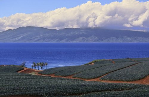 Pineapple cultivation used to be one of the largest industries on Maui. However, many pineapple businesses closed in the 2000s. Although there has been a resurgence in pineapple farming with hybrid grafting techniques, scenes like this one from 2000 have largely disappeared.
 During one of our many trips to Maui we rented a car and drove the back road to Hana, along Maui's north shore—including its 617 turns, 59 bridges, and over 52-miles of mostly dirt road. This pastoral scene from the Hana Highway depicts Maui's serene landscapes. I love the quiet pastel mood of this photo.
 During one of our many trips to Maui we rented a car and drove the back road to Hana, along Maui's north shore—including its 617 turns and 59 bridges over 52-miles of mostly dirt road. Off of a side road I spotted a make-shift junk yard of abandoned trucks. Need I say more? Also see 'Graffiti Truck' for another series of images from this shoot.
 During one of our many trips to Maui we rented a car and drove the back road to Hana, along Maui's north shore—including its 617 turns, 59 bridges, and over 52-miles of mostly dirt road. Off of a side road I spotted a make-shift junk yard of abandoned trucks. Need I say more? Also see 'Blue Truck' for another series of images from this shoot.
 During one of our many trips to Maui we rented a car and drove the back road to Hana, along Maui's north shore—including its 617 turns and 59 bridges over 52-miles of mostly dirt road. Off of a side road I spotted a make-shift junk yard of abandoned trucks. Need I say more? Also see 'Graffiti Truck' for another series of images from this shoot.
 During one of our many trips to Maui we rented a car and drove the back road to Hana, along Maui's north shore—including its 617 turns and 59 bridges over 52-miles of mostly dirt road. Off of a side road I spotted a make-shift junk yard of abandoned trucks. Need I say more? Also see 'Blue Truck' for another series of images from this shoot.
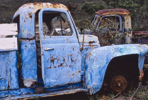 During one of our many trips to Maui we rented a car and drove the back road to Hana, along Maui's north shore—including its 617 turns and 59 bridges over 52-miles of mostly dirt road. Off of a side road I spotted a make-shift junk yard of abandoned trucks. Need I say more? Also see 'Graffiti Truck' for another series of images from this shoot.
 While visiting friends in Ellijay who rented a cabin there, we drove to Dawsonville. The owner of this 1937 Mercedes-Benz 540K Special Roadster had parked it just off the main square. The roadster's silver finish and elegant curves captured my interest.
 While visiting friends in Ellijay who rented a cabin there, we drove to Dawsonville. The owner of this 1937 Mercedes-Benz 540K Special Roadster had parked it just off the main square. The roadster's silver finish and elegant curves captured my interest.
 We drove to Amicalola Falls State Park while visiting friends who rented a cabin in Ellijay, Georgia. This vantage point of the 729-foot waterfall requires walking down 600-stairs to the base. Going down is not the problem.
 We drove to Amicalola Falls State Park while visiting friends who rented a cabin in Ellijay, Georgia. This image was taken on the trail from the lodge up to the falls. Here you will find the southern terminus of the 2,200 mile Appalachian Trail.
 Golden sun on the horizon just at sunset on Naples Beach, Florida. I made this image after Bekki and I had dinner in Naples. The beach is a short walk down Fifth Avenue.
 A wide stretch of white sand shaded pink in the setting sun at Naples Beach, Florida. I took this image after Bekki and I had dinner in Naples. Just walk Fifth Avenue west until you reach the Gulf.
 Children play in the surf, silhouetted by sunset at Alison Hagerup Beach on Captiva Island. Captiva is a 40-minute drive from our home in Southwest Florida (if you don't mind the $6 causeway toll). Image #3 of 3.
 This beautiful walkway along the beach can be found on Useppa Island—a little-known island located on the northern boundary of Pine Island Sound near Southwest Florida. Rising seas, around 4500 BC, disconnected Useppa from the mainland. Among other historical facts, the CIA used Useppa as its clandestine practice site for the failed Bay of Pigs invasion. Image #4 of 4.
 This beautiful walkway along the beach can be found on Useppa Island—a little-known island located on the northern boundary of Pine Island Sound in Southwest Florida. Rising seas, around 4500 BC, disconnected Useppa from the mainland. Among other historical facts, the CIA used Useppa as its clandestine practice site for the failed Bay of Pigs invasion. Image #3 of 4.
 This beautiful walkway along the beach can be found on Useppa Island—a little-known island located on the northern boundary of Pine Island Sound in Southwest Florida. Rising seas, around 4500 BC, disconnected Useppa from the mainland. Among other historical facts, the CIA used Useppa as its clandestine practice site for the failed Bay of Pigs invasion. Image #2 of 4.
 This beautiful walkway along the beach can be found on Useppa Island—a little-known island located on the northern boundary of Pine Island Sound in Southwest Florida. Rising seas, around 4500 BC, disconnected Useppa from the mainland. Among other historical facts, the CIA used Useppa as its clandestine practice site for the failed Bay of Pigs invasion. Image #1 of 4.
 Private home on Useppa Island—a little-known island located on the northern boundary of Pine Island Sound in Southwest Florida. Rising seas, around 4500 BC, disconnected Useppa from the mainland. Among other historical facts, the CIA used Useppa as its clandestine practice site for the failed Bay of Pigs invasion.
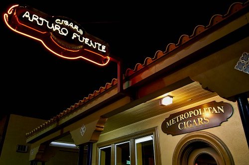 We lived in Tampa for a decade, adjacent to Ybor City which was once the cigar capital of the world. While not a cigar smoker myself, I find cigar culture photographically intriguing. Located in Ybor City, Arturo Fuente hand-rolled cigars are rated among the best in the world. Image #2 of 2.
 We lived in Tampa for a decade, adjacent to Ybor City which was once the cigar capital of the world. While not a cigar smoker myself, I find cigar culture photographically intriguing. Located in Ybor City, Arturo Fuente hand-rolled cigars are rated among the best in the world. Image #1 of 2.
 A sign in Key West reminds us of Cuba's close proximity to Florida. So close, yet so far.